Long before the war ended, it was obvious that the existing defence system was inadequate to protect the communications and population of Upper Canada. Many of the posts like Fort George and Fort Malden were earth and palisade fortifications which provided no protection against artillery. Others, like the fortifications at York, were incomplete and poorly armed. Over the course of the war many field fortifications and batteries were thrown up, the remains of two are still clearly visible in the Queenston Heights National Historic Park. More substantial works were begun at Kingston and Prescott.
The objective after the war was to limit the number of small garrisons, with main posts at Kingston and York to protect the naval yards and capital. This was part of a much greater military construction program which encompassed the Citadels at Quebec and Halifax, and Fort Lennox on the Richelieu River.
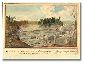
In addition to forts, the colonial government funded the construction of the Rideau Canal to provide for an alternate supply route between Lower and Upper Canada in the event of a future war, by-passing the St. Lawrence. Small garrisons were maintained at Prescott (Fort Wellington) and Niagara (Fort Mississauga) and a naval base with related fortifications was established at Penetanguishene on Nottawasaga Bay.
The naval race on the Great Lakes was effectively ended by the Rush Bagot Agreement in 1818, which established limits on the number and type of war vessels for each side on the lakes.

Click to see a larger image (239K)
Brewer's Lower Mill - view down the Cataraqui
Creek and clearing made for the Canal, 1829
Thomas Burrowes
Thomas Burrowes fonds
Watercolour
Reference Code: C 1-0-0-0-67
Archives of Ontario, I0002186
The frontier posts were maintained for many years, the size of garrisons fluctuating based on the state of international tensions. In the 1830s, 1840s and 1860s regular troops and militia with improved artillery were placed in the forts in response to border incursions (rebellion of 1837-1838; Fenian Raids, 1866) and the threat of war with the United States (Oregon Crisis, 1848).
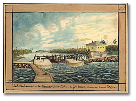
The Rideau Canal was built by the British Army in the 1820s to provide a more secure line of communications and supply between Montreal and Kingston. Blockhouses such as that shown in this illustration were built at several points to provide protection against raids.

Click to see a larger image (240K)
Lock, Blockhouse at the Narrows, Rideau Lake -
the first descent from Summit towards Bytown, 1841
Thomas Burrowes
Thomas Burrowes fonds
Watercolour
Reference Code: C 1-0-0-0-27
Archives of Ontario, I0002146
![Photo: Cannons at Fort Henry, Kingston, [ca. 1910] Photo: Cannons at Fort Henry, Kingston, [ca. 1910]](pics/c_130_1_0_15_65_ft_henry_270.jpg)
Click
to see a larger image (93K)
Cannons at Fort Henry, Kingston, [ca. 1910]
Marsden Kemp
Marsden Kemp fonds
Black and white print
Reference Code: C 130-1-0-15-65
Archives of Ontario, I0003974
Fort Henry was built as the centrepiece of the defence complex at Kingston designed to protect the navy yard and the southern entrance to the Rideau Canal. The most elaborate and largest of the post-war forts in Upper Canada, it was built over temporary defences put up during the war.

Click to see a larger image (45K)
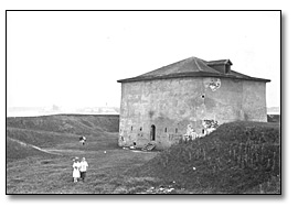
Martello Tower at Fort Mississauga,
Niagara-on-the-Lake, 1915
John Boyd
John Boyd fonds
Black and white print
Reference Code: C 7-3, 12061
Archives of Ontario, I0003522
Fort Mississauga was built in 1815 on a site occupied by a battery during the war; a brick and stone tower and earth work replaced Fort George to better counter the guns of Fort Niagara on the American side of the Niagara River. The post had a garrison until the 1840s. The remains of the fort are located on a golf course.
Fort York was expanded after the war and British troops continued to be garrisoned there until 1870 when it was transferred to the Canadian military. However, most of the garrison moved to the New Fort (Stanely Barracks) in 1841.
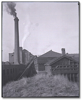
The City of Toronto purchased Fort York from the federal government at the beginning of the twentieth century, although the military continued to use the fort until the city restored it as an historic site between 1932 and 1934. The image to the right shows the fort in 1908 when industrial buildings were encroaching on the ramparts. Years later Hammond noted in a letter to Brigadier General E. A. Cruickshank,
Robert I. D. Gray to Mrs. Valentine (his sister), 16 February 1804

Click to
see a larger image (45K)
Fort York, Toronto, November 20, 1908
M. O. Hammond
M. O. Hammond fonds
Black and white negative
Reference Code: F 1075, H242
Archives of Ontario, I0000766
Changes in military technology made Fort York obsolete by the 1830s and a new, modern work was built as the main defence work west of Kingston.
![Sketch: Birds Eye View of the New Fort at Toronto, Upper Canada, [ca. 1841] Sketch: Birds Eye View of the New Fort at Toronto, Upper Canada, [ca. 1841]](pics/f_596_6706_fort_at_to_270.jpg)
Click to see a larger image (88K)
Birds Eye View of the New Fort at Toronto,
Upper Canada, [ca. 1841]
Thomas Glegg
Thomas Glegg fonds
Sketch
Reference Code: F 596
Archives of Ontario, I0006706
Located on the grounds of the Canadian National Exhibition the only structure connected to this fort still surviving is the Stanley Barracks.
- Good Defences Make Good Neighbours
- The Saga of Brock's Monument
- Memorials to the War
- Artists and Photographers