Populating the River Banks

Click to see a larger image (344K)
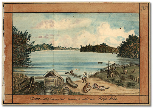
Clear Lake looking east towards its outlet into Wolfe Lake, 1835
Watercolour
Thomas Burrowes fonds
Reference Code: C 1-0-0-0-32
Archives of Ontario, I0002151
Completion of the Rideau Canal opened up a section of Upper Canada that had earlier only been accessible by canoe or on foot. Although by the 1830s much of the prime land in the area was owned by absentee landowners, the government expropriated most of the land bordering the canal and rented tracts of 20 acres for “commercial” purposes.
Despite the scarcity of arable land, settlers did come. Some of them settled on marginal land that was rocky and swampy. Others bought up or squatted on property that belonged to absentee owners. As a result, between 1834 and 1851, the sparsely populated Rideau Canal corridor more than tripled in population. Some of the canal workers – unskilled labourers, masons and demobilized military sappers and miners – settled there (and the beautiful, old stone buildings of eastern Ontario provide evidence that stonemasons continued to practice their craft).
New immigrants also arrived in the area from Ireland, refugees from that country’s potato famine. The Rideau Canal was completed in time to funnel them into a hard scrabble life that must have seemed promising at first glance when compared to their previous lives.
Vigorous settlements grew up around several lockstations, which became small commercial centres. Newboro, Westport and Smiths Falls thrived along with Merrickville, Burritts Rapids and Manotick (at the Long Island lockstation).
In general, however, the area did not flourish in the way that the more accessible and fertile areas of southwestern Upper Canada did. As an avenue of settlement, it seems, the Rideau Canal was not a grand success. Most people aboard the steamers and barges simply floated right past the rocky, forested shoreline and the flooded swampland, continuing on to Kingston, York and more prosperous parts of the province.

Click to see a larger image (303K)
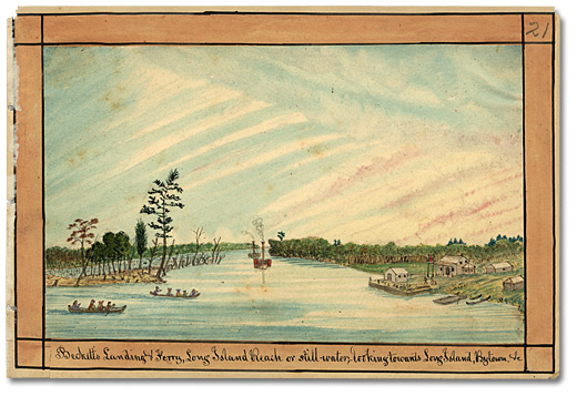
Beckett’s Landing & Ferry, Long Island Reach or
stillwater, looking towards Long Island, Bytown, &c, 1835
Watercolour
Thomas Burrowes fonds
Reference Code: C 1-0-0-0-21
Archives of Ontario, I0002140
Nevertheless, the Rideau proved a lifeline for settlers in the area who stayed close to the Rideau waterway, as their only connection to the outside world. Those who carved farmsteads out of the wilderness depended for supplies on the small settlements that grew up around wharves on the waterway. They bought many necessities, including cloth and tools, at outpost stores; and they sold vegetables, wheat and potash (from wood ashes) to storekeepers who used the canal to ship produce to Bytown to feed the lumber camps that were booming throughout the Ottawa Valley.