Table of Contents
Making Contact | Transitions | Resources and Trade
People, Places and Times | War and Defence | To Learn More
|
Much of the history of New France was marked by war or the threat of war with First Nations or the British. The need to prevent attacks by hostile First Nations and to check British expansion, combined with commercial interests, resulted in the building of forts throughout the interior. By the mid-18th century, the entrances to New France were in British hands, but the French presence was still felt throughout the Great Lakes area, the Ohio Valley and along the Mississippi River. |
||||||||

|
||||||||
|
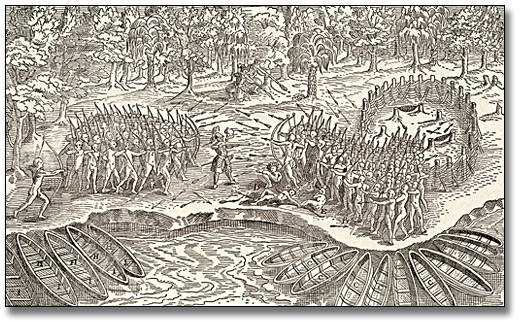
When Champlain originally founded Quebec, he became involved in wars between First Nations. In 1609, he joined the Algonquin and other nations in their alliance against the Iroquois. The battle illustrated below, which took place in 1609 at Lake Champlain, was the precursor to wars in which the Iroquois fought the French and their First Nations allies for most of the 17th century. |
||||||||
Click to see a larger image (718K) |
||||||||
|
These wars caused the weakening or destruction of most First Nations of the Great Lakes and Upper Ohio areas. French settlers lived in fear of the next Iroquois attack. French offensives against the Iroquois could be devastating as well, as shown in this account of a 1687 campaign: |
||||||||
|
||||||||
|
The Great Peace of Montreal (1701) ended the French-Iroquois war. The expansion of French trade and alliances during the 18th century would result in wars with some First Nations west and south of the Great Lakes, but their impact would be mostly limited to the interior. |
||||||||

|
||||||||
|
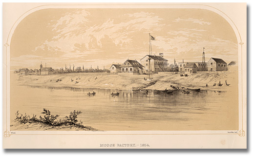
France’s other great enemy in North America was Great Britain and for most of the 18th century the two nations were at war either directly or indirectly through their allies. Alliances with First Nations, conflicting economic interests, and European rivalry would contribute to the tension. The Hudson Bay area, because of its importance as a route to the interior, was one of the first areas of direct conflict. In 1686, a French expedition sent overland from Montreal attacked British forts on Hudson and James Bays. One of the posts captured was Moose Factory, shown here as it appeared in the 19th century. |
|
|||||||
|
|
||||||||
|
|
||||||||
|
The commander of the expedition, the Chevalier de Troyes, left a colourful account of it. Here is how he described the capture of Fort Rupert on July 3rd, 1686. |
||||||||
|
||||||||
|
Hudson Bay forts would change hands a number of times during the wars of the League of Augsburg (1689-1697) and Spanish Succession (1701-1713). The Treaty of Utrecht (1713) awarded them, along with Acadia (current day Nova Scotia) and Newfoundland, to Great Britain. French and British would fight two other wars, the War of Austrian Succession (1741-1748) and the Seven Years War (1756-1763), the latter resulting in France’s loss of its North American colonies. |
||||||||

|
||||||||
|
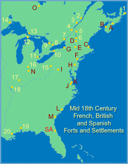
Commercial and strategic imperatives led the French to build a network of forts and trading posts throughout the interior. The aims were to control the fur trade, assist allied First Nations and threaten hostile ones, provide support to explorers and missionaries, and prevent English trade and influence. The first forts, built between the 1660’s and the end of the century, were for the most part abandoned as a result of the Iroquois wars and French attempts to redirect trade towards Montreal. After the Treaty of Utrecht, the need for expansion to counter the growing British presence in the interior led to more forts and posts being built or re-built. |
|
|||||||
|
By 1755, there were French forts and trading posts as far west as today’s Saskatchewan and Kansas. On the Great Lakes, Forts Frontenac (now Kingston), Niagara, Michilimakinac, Detroit and, to a lesser degree, Rouillé (Toronto), were important transit points for merchants, soldiers and administrators. The lower Great Lakes and Ohio Valley were a strategic area, linking New France and Louisiana, and which could block British expansion. |
||||||||
|
||||||||
|
Note: The map legend refers to the settlements as the existed in the mid-1750s. Click on the map to learn more about the forts and settlements. |
||||||||
|
||||||||
|
|
||||||||
|
||||||||
|
|
||||||||
|
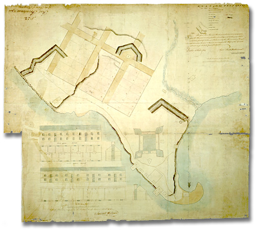
Fort Frontenac, first built in 1673 and re-built in 1693, was originally a trading post, military outpost against the Iroquois and exploration base. Its location at the entrance of the St. Lawrence made it a key transit point between Montreal, Detroit and the Ohio Valley. This 1784 plan shows the site of the fort, still in use by the British after the Conquest. |
||||||||
|
|
||||||||
|
Previous | Home | Next |
||||||||
![Photo: Old Factory House in the winter in Moose Factory, [ca. 1967]](pics/5074_moose_factory_270.jpg)
